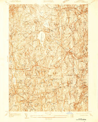
1937 Map of Leicester
USGS Topo · Published 1937About this map
Leicester and its surrounding Worcester County townships are defined by a complex landscape of glacial hills and industrious mill settlements in this 1937 survey. The industrial legacy of the region is evident in the concentration of village clusters like Cherry Valley and Rochdale, which grew alongside water sources and the Albany & Boston RR. Social and community structures are well-documented, from the Clark Barton Home and Charlton Home Farm to local educational landmarks such as School No 4 and the Woodward Sch.
Find a feature on this map
149 named features on this map. Tap any name to fly to it.
Don’t see what you’re looking for? This feature index may not catch every label — zoom into the map to look around manually.
Map Details
Editions of this 1937 Leicester Map
This is the sole edition of this map. No revisions or reprints were ever made.
Other maps of this area

1885 · Worcester
USGS Topo · 1:62,500

1886 · Worcester
USGS Topo · 1:62,500

1887 · Brookfield
USGS Topo · 1:62,500

1887 · Barre
USGS Topo · 1:62,500

1889 · Webster
USGS Topo · 1:62,500

1889 · Barre
USGS Topo · 1:62,500

1890 · Brookfield
USGS Topo · 1:62,500

1892 · Webster
USGS Topo · 1:62,500

1892 · Worcester
USGS Topo · 1:62,500

1893 · Brookfield
USGS Topo · 1:62,500