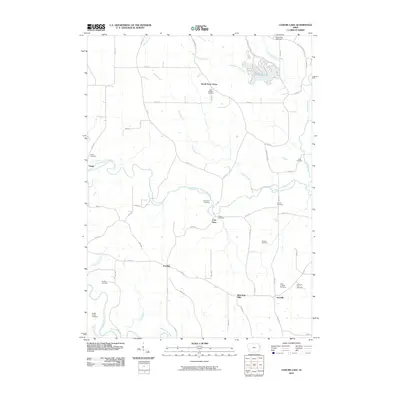
2010 Map of Leisure Lake
USGS Topo · Published 2010About this map
The North Fork Maquoketa River and its tributary Cline Branch carve a winding path through this Iowa landscape, defining the rural character of Jackson County. Near the northern boundary, the residential development around Leisure Lake contrasts with the surrounding agricultural land, supported by the Schwenker Lake Dam on the North Spring Branch. The map reveals a dense network of family and community landmarks, particularly evident in the high concentration of small burial sites such as the Tracy Farm Cemetery, Streets Cemetery, and Crabb Cemetery. Small settlements like Crab Town, Emeline, and South Garry Owen serve as anchor points along the section-line roads, while larger watercourses like the Maquoketa River and Pine Creek dominate the southwestern quadrant, illustrating the historical importance of these drainage systems to local settlement patterns.
Find a feature on this map
62 named features on this map. Tap any name to fly to it.
Don’t see what you’re looking for? This feature index may not catch every label — zoom into the map to look around manually.
Map Details
Editions of this 2010 Leisure Lake Map
This is the sole edition of this map. No revisions or reprints were ever made.
Other maps of this area

1891 · Maquoketa
USGS Topo · 1:62,500

1891 · Baldwin
USGS Topo · 1:62,500

1901 · Peosta
USGS Topo · 1:125,000

1935 · East Dubuque
USGS Topo · 1:62,500

1940 · East Dubuque
USGS Topo · 1:62,500

1959 · Dubuque
USGS Topo · 1:250,000

1961 · Dubuque
USGS Topo · 1:250,000

1962 · Dubuque
USGS Topo · 1:250,000

1962 · Zwingle
USGS Topo · 1:24,000
1966 · Bernard
USGS Topo · 1:24,000