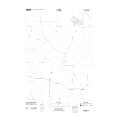
2013 Map of Leisure Lake
USGS Topo · Published 2013About this map
Leisure Lake serves as a modern residential anchor in the northern reaches of this Jackson County landscape, with a dense network of local roads such as Lake Shore Dr and Pleasant Dr surrounding its waters. Moving south, the terrain opens into a series of smaller rural nodes including Crab Town, Emeline, and South Garry Owen, illustrating the persistent settlement patterns of eastern Iowa. The Maquoketa River and its N Fork carve through the center of the sheet, joined by smaller tributaries like Pine Cr and Cline Br. This hydrography once dictated the placement of historic hamlets like Ozark, situated near Ozark Springs. To the southeast, the geography transitions toward the community of Ironhills, where agricultural roads connect the upland reaches between Lytle Cr and the river valley.
Find a feature on this map
85 named features on this map. Tap any name to fly to it.
Don’t see what you’re looking for? This feature index may not catch every label — zoom into the map to look around manually.
Map Details
Editions of this 2013 Leisure Lake Map
This is the sole edition of this map. No revisions or reprints were ever made.
Other maps of this area

1891 · Maquoketa
USGS Topo · 1:62,500

1891 · Baldwin
USGS Topo · 1:62,500

1901 · Peosta
USGS Topo · 1:125,000

1935 · East Dubuque
USGS Topo · 1:62,500

1940 · East Dubuque
USGS Topo · 1:62,500

1959 · Dubuque
USGS Topo · 1:250,000

1961 · Dubuque
USGS Topo · 1:250,000

1962 · Dubuque
USGS Topo · 1:250,000

1962 · Zwingle
USGS Topo · 1:24,000
1966 · Bernard
USGS Topo · 1:24,000