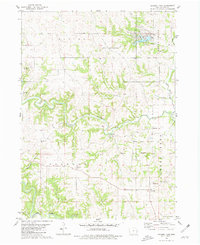
1980 Map of Leisure Lake
USGS Topo · Published 1981About this map
North Fork Maquoketa River and its numerous tributaries, including Clove Branch, Black Hawk Creek, and Pine Creek, carve a deep drainage system through this portion of Jackson County. The landscape is defined by the winding river valleys and the upland settlements that connect them, such as Emeline and South Garry Owen. Local history is anchored by rural institutions like St Aloysius Ch and a collection of family and community burial grounds, including Crabb Cem, Said Cem, and the West Ironhills Cem.
Find a feature on this map
30 named features on this map. Tap any name to fly to it.
Don’t see what you’re looking for? This feature index may not catch every label — zoom into the map to look around manually.
Map Details
Editions of this 1980 Leisure Lake Map
This is the sole edition of this map. No revisions or reprints were ever made.
Other maps of this area

1891 · Maquoketa
USGS Topo · 1:62,500

1891 · Baldwin
USGS Topo · 1:62,500

1901 · Peosta
USGS Topo · 1:125,000

1935 · East Dubuque
USGS Topo · 1:62,500

1940 · East Dubuque
USGS Topo · 1:62,500

1959 · Dubuque
USGS Topo · 1:250,000

1961 · Dubuque
USGS Topo · 1:250,000

1962 · Dubuque
USGS Topo · 1:250,000

1962 · Zwingle
USGS Topo · 1:24,000
1966 · Bernard
USGS Topo · 1:24,000