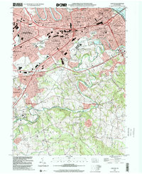
1999 Map of Lemoyne
USGS Topo · Published 2001About this map
The Susquehanna River and Yellow Breeches Creek define the physical and jurisdictional landscape of this region on the eve of the millennium. The densely settled corridor of Lemoyne, Camp Hill, and Shiremanstown shows the intricate grid of the West Shore’s growth, while the Mechanicsburg Naval Supply Center and the State Correctional Institution highlight the significant institutional footprint in the area. Local transit is dominated by the Pennsylvania Turnpike and the Norfolk Southern rail lines, which cut through older communities like Highland Park and White Hill.
Find a feature on this map
80 named features on this map. Tap any name to fly to it.
Don’t see what you’re looking for? This feature index may not catch every label — zoom into the map to look around manually.
Map Details
Editions of this 1999 Lemoyne Map
This is the sole edition of this map. No revisions or reprints were ever made.
Other maps of this area

1892 · Harrisburg
USGS Topo · 1:62,500

1899 · Harrisburg
USGS Topo · 1:62,500

1904 · Carlisle
USGS Topo · 1:62,500

1906 · New Cumberland
USGS Topo · 1:62,500

1907 · New Bloomfield
USGS Topo · 1:62,500

1924 · Harrisburg
USGS Topo · 1:62,500

1943 · New Cumberland
USGS Topo · 1:62,500

1943 · Harrisburg
USGS Topo · 1:62,500

1943 · New Bloomfield
USGS Topo · 1:62,500

1943 · Carlisle
USGS Topo · 1:62,500