
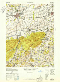
1943 Map of Carlisle
USGS Topo · Published 1944About this map
Carlisle Barracks and the Pennsylvania Turnpike anchor the northern landscape of this wartime survey, illustrating the critical junction of military presence and modern infrastructure. The turnpike, shown with its Carlisle Interchange and Middlesex Interchange, cuts through the Cumberland Valley, intersecting older routes like the Chambersburg Pike and York Road. The industrial legacy of the region is visible at the Reading Banks iron ore sites and the various stations along the Reading RR, such as Leidighs Sta and Barnitz.
Find a feature on this map
135 named features on this map. Tap any name to fly to it.
Don’t see what you’re looking for? This feature index may not catch every label — zoom into the map to look around manually.
Map Details
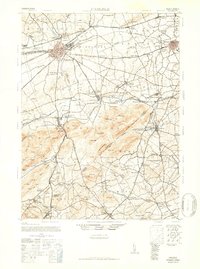
Editions of this 1943 Carlisle Map
3 editions found
Other maps of this area

1892 · Harrisburg
USGS Topo · 1:62,500

1899 · Harrisburg
USGS Topo · 1:62,500

1904 · Carlisle
USGS Topo · 1:62,500

1906 · New Cumberland
USGS Topo · 1:62,500

1907 · New Bloomfield
USGS Topo · 1:62,500

1908 · Gettysburg
USGS Topo · 1:62,500

1909 · Fairfield
USGS Topo · 1:62,500

1919 · Newville
USGS Topo · 1:62,500

1920 · Hanover
USGS Topo · 1:62,500

1922 · Hanover
USGS Topo · 1:62,500
Featured Places
- Carlisle, PA
- Middlesex Township, PA
- Schlusser, PA
- Boiling Springs, South Middleton Township
- Latimore Township, PA