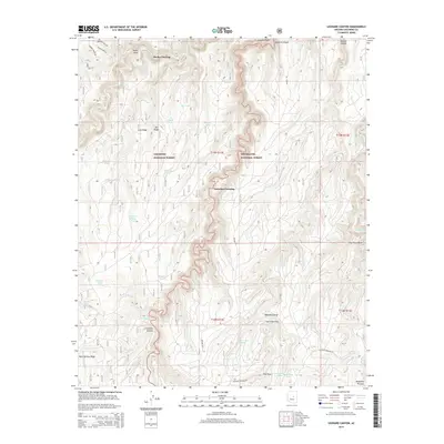
2014 Map of Leonard Canyon
USGS Topo · Published 2014About this map
Coconino National Forest and Sitgreaves National Forest meet along the dramatic divide of Leonard Canyon, a deep drainage cutting through the Mogollon Plateau. This 2014 survey documents the remote network of resource management tanks and historic crossings that define this high-country landscape. Traditional routes like Soldier Trl and Wiggins Crossing Rd traverse the ridges, connecting points of interest such as Macks Crossing and Victorine Crossing. The map identifies numerous water management features essential to the region's ranching and forestry history, including Second Chance Tank, Saltground Tank, and Pius Tank. Notable landmarks like the Chavez Shrine and Leonard Point provide specific geographic anchors for researchers and local historians exploring the upper reaches of E Clear Cr.
Find a feature on this map
46 named features on this map. Tap any name to fly to it.
Don’t see what you’re looking for? This feature index may not catch every label — zoom into the map to look around manually.
Map Details
Editions of this 2014 Leonard Canyon Map
This is the sole edition of this map. No revisions or reprints were ever made.
Other maps of this area

1886 · Holbrook
USGS Topo · 1:250,000

1887 · Verde
USGS Topo · 1:250,000

1892 · Verde
USGS Topo · 1:250,000

1893 · Holbrook
USGS Topo · 1:250,000

1934 · Promontory Butte
USGS Topo · 1:62,500

1939 · Promontory Butte
USGS Topo · 1:62,500

1952 · Promontory Butte
USGS Topo · 1:62,500

1954 · Holbrook
USGS Topo · 1:250,000

1957 · Holbrook
USGS Topo · 1:250,000

1958 · Holbrook
USGS Topo · 1:250,000