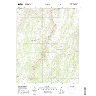
2018 Map of Leonard Canyon
USGS Topo · Published 2018About this map
Coconino National Forest and Sitgreaves National Forest meet along the dramatic incisions of the Mogollon Plateau. This high-country landscape is defined by the deep, winding course of Leonard Canyon, which serves as a natural boundary between the two forest jurisdictions. Historically significant travel and water management patterns are visible through labels like Victorine Crossing and a network of livestock water features including Victorine Tank, Morgan Tank, and Buckhorn Tank. The topography is marked by prominent high points such as Leonard Point and long, flat-topped divides like Cave Ridge and Cart Ridge. These features illustrate the land's transition from the high plateau into a series of complex drainage systems, including Limestone Canyon and Moqui Draw. Isolated water sources like Chavez Spring and Spaulding Spring indicate the critical points of hydration in this arid upland environment.
Find a feature on this map
35 named features on this map. Tap any name to fly to it.
Don’t see what you’re looking for? This feature index may not catch every label — zoom into the map to look around manually.
Map Details
Editions of this 2018 Leonard Canyon Map
This is the sole edition of this map. No revisions or reprints were ever made.
Other maps of this area

1886 · Holbrook
USGS Topo · 1:250,000

1887 · Verde
USGS Topo · 1:250,000

1892 · Verde
USGS Topo · 1:250,000

1893 · Holbrook
USGS Topo · 1:250,000

1934 · Promontory Butte
USGS Topo · 1:62,500

1939 · Promontory Butte
USGS Topo · 1:62,500

1952 · Promontory Butte
USGS Topo · 1:62,500

1954 · Holbrook
USGS Topo · 1:250,000

1957 · Holbrook
USGS Topo · 1:250,000

1958 · Holbrook
USGS Topo · 1:250,000