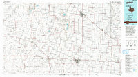
1985 Map of Levelland
USGS Topo · Published 1993About this map
Levelland serves as the focal point of this High Plains region, showcasing the intersection of education at South Plains College and the intensive energy industry of the Levelland and Slaughter Oil and Gas Field. The map illustrates a landscape defined by the distinct drainage patterns of Yellow House Draw and Sulphur Draw, which carve through the grid-like settlement patterns typical of the Texas Panhandle. Small communities such as Oklahoma Flat, Whitharral, and Pep are connected by a network of straight-line roads, revealing the agricultural and petroleum-based economy of the mid-1980s.
Find a feature on this map
54 named features on this map. Tap any name to fly to it.
Don’t see what you’re looking for? This feature index may not catch every label — zoom into the map to look around manually.
Map Details
Editions of this 1985 Levelland Map
2 editions found
Historical Maps of Lubbock Through Time
1 maps found