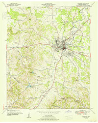
1951 Map of Lewisburg
USGS Topo · Published 1951About this map
Lewisburg serves as the focal point of this mid-century Marshall County survey, where the Nashville Chattanooga and St. Louis railway meets the Louisville and Nashville line. This intersection supported a bustling local economy, evidenced by the central business district, the Lewisburg Airport, and the nearby U S Experimental Dairy Farm. The map reveals a deeply rooted rural community, with family names preserved in features like Barron Hill and McDaniel Hollow.
Find a feature on this map
79 named features on this map. Tap any name to fly to it.
Don’t see what you’re looking for? This feature index may not catch every label — zoom into the map to look around manually.
Map Details
Editions of this 1951 Lewisburg Map
This is the sole edition of this map. No revisions or reprints were ever made.
Other maps of this area

1936 · Farmington
USGS Topo · 1:24,000

1936 · Belfast
USGS Topo · 1:24,000

1936 · Cornersville
USGS Topo · 1:24,000

1936 · Lewisburg
USGS Topo · 1:24,000

1936 · Brick Church
USGS Topo · 1:24,000

1936 · Verona
USGS Topo · 1:24,000

1936 · Campbells Station
USGS Topo · 1:24,000

1936 · Petersburg
USGS Topo · 1:24,000

1936 · Glendale
USGS Topo · 1:24,000

1944 · Shelbyville
USGS Topo · 1:100,000