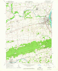
1965 Map of Lewisburg
USGS Topo · Published 1967About this map
Lewisburg serves as the prominent center of this mid-1960s landscape, situated along the West Branch Susquehanna River and dominated by the campus of Bucknell University. The town's grid gives way to the expansive Buffalo Valley, where agricultural patterns are punctuated by numerous rural congregations such as Emmanuel Ch and Dreisbach Ch. To the north, the massive facility of the Northeast Federal Penitentiary occupies a large tract near Kelly Point.
Find a feature on this map
62 named features on this map. Tap any name to fly to it.
Don’t see what you’re looking for? This feature index may not catch every label — zoom into the map to look around manually.
Map Details
Editions of this 1965 Lewisburg Map
2 editions found
Other maps of this area

1893 · Sunbury
USGS Topo · 1:62,500

1921 · Williamsport
USGS Topo · 1:48,000

1923 · Williamsport
USGS Topo · 1:62,500

1924 · Milton
USGS Topo · 1:62,500

1938 · Mifflinburg
USGS Topo · 1:48,000

1943 · Sunbury
USGS Topo · 1:62,500

1943 · Mifflinburg
USGS Topo · 1:62,500

1944 · Williamsport
USGS Topo · 1:62,500

1950 · Harrisburg
USGS Topo · 1:250,000
1953 · Mifflinburg
USGS Topo · 1:62,500
Featured Places
- Lewisburg, PA
- Monroe Township, PA
- Buffalo Township, PA
- Buffalo Crossroads, Buffalo Township
- Lochiel, East Buffalo Township