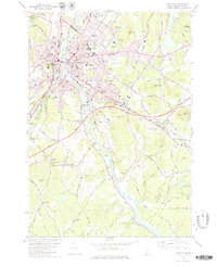
1979 Map of Lewiston
USGS Topo · Published 1979About this map
Bates College stands as a central landmark in this late-1970s view of the twin cities, where the Androscoggin River separates Auburn and Lewiston. The landscape is tied together by the Maine Turnpike and a network of bridges, including the Vietnam Veterans Memorial Bridge and the South Bridge. Beyond the urban core, the map reveals a series of historic crossroads and rural settlements like Penley Corner, Murphy Corner, and Rumford Junction, documenting the expansion of the region's residential and industrial footprint.
Find a feature on this map
86 named features on this map. Tap any name to fly to it.
Don’t see what you’re looking for? This feature index may not catch every label — zoom into the map to look around manually.
Map Details
Editions of this 1979 Lewiston Map
2 editions found
Other maps of this area

1892 · Freeport
USGS Topo · 1:62,500

1894 · Gray
USGS Topo · 1:62,500

1898 · Gray
USGS Topo · 1:62,500

1908 · Poland
USGS Topo · 1:62,500

1908 · Lewiston
USGS Topo · 1:62,500

1940 · Poland
USGS Topo · 1:62,500

1941 · Freeport
USGS Topo · 1:62,500

1942 · Lewiston
USGS Topo · 1:62,500

1942 · Poland
USGS Topo · 1:62,500

1942 · Gray
USGS Topo · 1:62,500