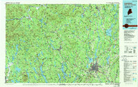
1986 Map of Lewiston
USGS Topo · Published 1988About this map
The Androscoggin River carves a path through the heart of this landscape, anchoring the industrial and educational hubs of Auburn and Lewiston. This late-1980s snapshot of south-central Maine reveals a region defined by its prominent valley corridors and the upland peaks of the Oxford Hills. Higher education and specialized institutions are notable landmarks, including Bates College in Lewiston and the prestigious Hebron Academy and Gould Academy.
Find a feature on this map
163 named features on this map. Tap any name to fly to it.
Don’t see what you’re looking for? This feature index may not catch every label — zoom into the map to look around manually.
Map Details
Editions of this 1986 Lewiston Map
2 editions found
Other maps of this area

1892 · Gardiner
USGS Topo · 1:62,500

1892 · Freeport
USGS Topo · 1:62,500

1892 · Augusta
USGS Topo · 1:62,500

1893 · Gorham
USGS Topo · 1:62,500

1894 · Norridgewock
USGS Topo · 1:62,500

1894 · North Conway
USGS Topo · 1:62,500

1894 · Gray
USGS Topo · 1:62,500

1894 · Bath
USGS Topo · 1:62,500

1896 · Norway
USGS Topo · 1:62,500

1896 · Sebago
USGS Topo · 1:62,500