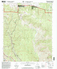
1995 Map of Liebre Mountain
USGS Topo · Published 1999About this map
Liebre Mountain and the surrounding Angeles National Forest define this landscape along the tectonic boundary of the San Andreas Rift Zone. Historical travel through these northern mountains is documented by the path of the Old Ridge Route, where travelers once stopped at local waypoints like the Tumble Inn and Halfway Inn. Higher elevations host the U S Weather Bureau Station near Sandberg, while the modern California Aqueduct cuts through the northern terrain, indicating the region's vital role in water infrastructure.
Find a feature on this map
50 named features on this map. Tap any name to fly to it.
Don’t see what you’re looking for? This feature index may not catch every label — zoom into the map to look around manually.
Map Details
Editions of this 1995 Liebre Mountain Map
This is the sole edition of this map. No revisions or reprints were ever made.
Other maps of this area

1903 · Tejon
USGS Topo · 1:125,000

1931 · Redrock Mtn
USGS Topo · 1:24,000

1932 · Beartrap Canyon
USGS Topo · 1:24,000

1932 · Neenach
USGS Topo · 1:24,000

1933 · Quail
USGS Topo · 1:24,000
1936 · Redrock Mtn.
USGS Topo · 1:24,000

1938 · Beartrap Canyon
USGS Topo · 1:24,000

1938 · Liebre
USGS Topo · 1:24,000

1938 · Quail
USGS Topo · 1:24,000

1943 · Neenach
USGS Topo · 1:62,500