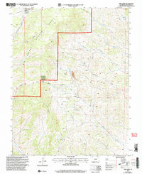
2001 Map of Lime Creek
USGS Topo · Published 2005About this map
Rio Grande National Forest dominates this Saguache County landscape, revealing a network of drainages and working land-use patterns in the Colorado high country at the turn of the millennium. The topography is defined by the convergence of several major watercourses, including Carnero Creek, Cottonwood Creek, and the namesake Lime Creek. A notable legacy of the region's ranching history is the Stock Driveway that traverses the central portion of the map, providing a glimpse into the seasonal movement of livestock through the national forest.
Find a feature on this map
20 named features on this map. Tap any name to fly to it.
Don’t see what you’re looking for? This feature index may not catch every label — zoom into the map to look around manually.
Map Details
Editions of this 2001 Lime Creek Map
This is the sole edition of this map. No revisions or reprints were ever made.
Other maps of this area

1915 · Del Norte
USGS Topo · 1:125,000

1917 · Del Norte
USGS Topo · 1:125,000

1945 · Durango
USGS Topo · 1:250,000

1953 · Durango
USGS Topo · 1:250,000

1954 · Durango
USGS Topo · 1:250,000

1956 · Montrose
USGS Topo · 1:250,000

1959 · Montrose
USGS Topo · 1:250,000

1960 · Montrose
USGS Topo · 1:250,000

1961 · Durango
USGS Topo · 1:250,000

1963 · Durango
USGS Topo · 1:250,000