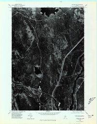
1975 Map of Lincoln SW
USGS Topo · Published 1980About this map
The Penobscot River flows through this 1975 aerial perspective of central Maine, marking a landscape defined by its deep woods and significant waterways. This orthophotoquad provides a clear view of the confluence where the Piscataquis River meets the Penobscot, a site of long-standing importance for regional transport and the logging industry. To the north, the southern reaches of Cold Stream Lake punctuate the dense forest cover. The imagery captures the winding path of the river channels and the developed corridor of road infrastructure that shadows the water, reflecting the area's mid-century reliance on both its natural resources and modern transportation networks. This specific survey serves as a visual census of the Maine wilderness and rural development just before the transition into the 1980s.
Find a feature on this map
3 named features on this map. Tap any name to fly to it.
Don’t see what you’re looking for? This feature index may not catch every label — zoom into the map to look around manually.
Map Details
Editions of this 1975 Lincoln SW Map
This is the sole edition of this map. No revisions or reprints were ever made.
Other maps of this area

1917 · Passadumkeag
USGS Topo · 1:62,500

1933 · Boyd Lake
USGS Topo · 1:62,500

1942 · Lincoln
USGS Topo · 1:62,500

1947 · Schoodic
USGS Topo · 1:62,500

1949 · Schoodic
USGS Topo · 1:62,500

1951 · Boyd Lake
USGS Topo · 1:50,000

1954 · Millinocket
USGS Topo · 1:250,000

1955 · Boyd Lake
USGS Topo · 1:62,500

1957 · Lincoln
USGS Topo · 1:62,500

1958 · Millinocket
USGS Topo · 1:250,000