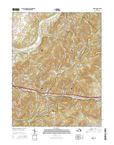
2016 Map of Linden
USGS Topo · Published 2016About this map
Shenandoah Farms and several mountain-side developments anchor this topographic study of the Blue Ridge foothills during the mid-2010s. The landscape is defined by its transition from the Shenandoah River in the northwest to the high ridges of the Blue Mountain and Blue Ridge ranges. This area serves as a significant corridor for both ancient geography and modern transit, featuring the historic passage at Manassas Gap and the meandering route of the Appalachian National Scenic Trail. Local genealogy and land use patterns are visible through family-named sites like Howellsville Cem and Hardscrabble Cem, alongside water bodies such as Loch Linden Lake and Apple Mountain Lake. The concentration of settlements like Linden, Markham, and Skyland Estates illustrates the residential growth within these hollows, including Snake Hollow and Trumbo Hollow, where the terrain dictates the winding path of local roads.
Find a feature on this map
63 named features on this map. Tap any name to fly to it.
Don’t see what you’re looking for? This feature index may not catch every label — zoom into the map to look around manually.
Map Details
Editions of this 2016 Linden Map
This is the sole edition of this map. No revisions or reprints were ever made.
Other maps of this area

1884 · Harpers Ferry
USGS Topo · 1:125,000

1891 · Harpers Ferry
USGS Topo · 1:125,000

1893 · Luray
USGS Topo · 1:125,000

1893 · Harpers Ferry
USGS Topo · 1:125,000

1894 · Warrenton
USGS Topo · 1:125,000

1894 · Winchester
USGS Topo · 1:125,000

1905 · Luray
USGS Topo · 1:125,000

1916 · Berryville
USGS Topo · 1:62,500

1938 · Winchester
USGS Topo · 1:48,000

1939 · Front Royal
USGS Topo · 1:48,000