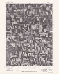
1977 Map of Lindy
USGS Topo · Published 1979About this map
The small settlement of Lindy serves as the focal point of this 1970s orthophotograph, centered in a landscape of highly structured agricultural production in Knox County. Produced in cooperation with the Bureau of Indian Affairs, this survey uses aerial imagery to reveal the precise layout of section lines, farmsteads, and the varied textures of Nebraska cropland during the late twentieth century. The imagery captures a moment of transition where the systematic geometry of field borders meets the natural drainage patterns of the northern plains. Because this is an orthophotograph rather than a standard line map, it offers a literal visual record of the vegetation and land use across the Lindy quadrangle, documenting the exact footprint of human habitation and agriculture as it existed in the summer of 1977.
Find a feature on this map
1 named feature on this map. Tap any name to fly to it.
Don’t see what you’re looking for? This feature index may not catch every label — zoom into the map to look around manually.
Map Details
Editions of this 1977 Lindy Map
This is the sole edition of this map. No revisions or reprints were ever made.
Other maps of this area

1955 · Sioux City
USGS Topo · 1:250,000

1958 · Sioux City
USGS Topo · 1:250,000

1959 · Sioux City
USGS Topo · 1:250,000

1968 · Tabor SE
USGS Topo · 1:24,000

1968 · Bloomfield NE
USGS Topo · 1:24,000

1968 · Bloomfield SE
USGS Topo · 1:24,000

1974 · Lindy
USGS Topo · 1:24,000

1974 · Bloomfield
USGS Topo · 1:24,000
1974 · Center East
USGS Topo · 1:24,000

1974 · Howe Creek
USGS Topo · 1:24,000