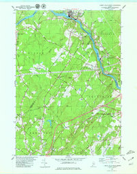
1979 Map of Lisbon Falls South
USGS Topo · Published 1979About this map
The Androscoggin River carves through the landscape of the late 1970s, serving as a boundary between several Maine towns and counties. This survey shows the industrial and community hubs of Lisbon Falls and Pejepscot as they were organized around the Maine Central railroad corridor and the river's power. Away from the water, the terrain transitions into a patchwork of rural cemeteries and family landmarks like Vining Cem, Littlefield Cem, and the Plummer Mill site. Local history is etched into the landscape through features like the Shiloh church and several named heights such as Cox Pinnacle and Bald Rock. The map records a mix of traditional land use, represented by numerous Gravel Pits, alongside mid-century developments like the Drive-in Theater near Hillside, reflecting the evolving character of Durham and Brunswick during this era.
Find a feature on this map
58 named features on this map. Tap any name to fly to it.
Don’t see what you’re looking for? This feature index may not catch every label — zoom into the map to look around manually.
Map Details
Editions of this 1979 Lisbon Falls South Map
3 editions found
Other maps of this area

1892 · Gardiner
USGS Topo · 1:62,500

1892 · Freeport
USGS Topo · 1:62,500

1894 · Bath
USGS Topo · 1:62,500

1908 · Lewiston
USGS Topo · 1:62,500

1920 · Bath
USGS Topo · 1:62,500

1941 · Freeport
USGS Topo · 1:62,500

1942 · Lewiston
USGS Topo · 1:62,500

1943 · Gardiner
USGS Topo · 1:62,500

1944 · Freeport
USGS Topo · 1:62,500

1945 · Bath
USGS Topo · 1:62,500