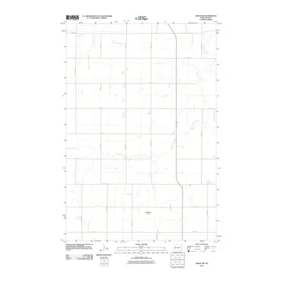
2011 Map of Lisbon SW
USGS Topo · Published 2011About this map
Dead Colt Creek meanders through this portion of Sargent County, defining the drainage patterns of an agricultural landscape just south of Lisbon. The terrain is characterized by the Whitestone Hills, which rise in the southern portion of the quadrangle. This 2011 survey by the U.S. Geological Survey illustrates a highly organized section-line road network, including 128th Ave SE and 131st Ave SE, which partition the land into the precise grids typical of the Great Plains. These corridors, such as 77th St SE, reveal the enduring structure of rural North Dakota settlement and land management. The map serves as a primary source for understanding the modern hydrology and topographical features that have influenced farming and local transit in the Gwinner area for generations.
Find a feature on this map
17 named features on this map. Tap any name to fly to it.
Don’t see what you’re looking for? This feature index may not catch every label — zoom into the map to look around manually.
Map Details
Editions of this 2011 Lisbon SW Map
This is the sole edition of this map. No revisions or reprints were ever made.
Other maps of this area

1953 · Fargo
USGS Topo · 1:250,000

1956 · Fargo
USGS Topo · 1:250,000

1957 · Stirum
USGS Topo · 1:24,000

1957 · Elliott SE
USGS Topo · 1:24,000

1960 · Lisbon SE
USGS Topo · 1:24,000

1960 · Lisbon NE
USGS Topo · 1:24,000

1962 · Lisbon
USGS Topo · 1:24,000
1962 · Hoving
USGS Topo · 1:24,000

1962 · Lisbon SW
USGS Topo · 1:24,000

1962 · Elliott
USGS Topo · 1:24,000
Featured Places
- Gwinner, ND
- Willey Township, ND
- Aliceton Township, ND
- Whitestone Hill Township, ND
- Island Park Township, ND