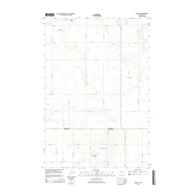
2014 Map of Lisbon SW
USGS Topo · Published 2014About this map
Gwinner serves as the primary center of activity in this corner of the Dakota plains, situated just south of the rising Whitestone Hills. This 2014 survey documents a landscape of precise section lines and agricultural efficiency, where a network of gravel roads like 128th Ave SE and 77th St SE grid the terrain. The erratic path of Dead Colt Cr cuts across these man-made boundaries, winding through the eastern and central portions of the quadrangle and into the neighboring Timber Coulee drainage. Local aviation is anchored by the Moellenkamp Airport in the northwest, providing a vital connection for this rural community. The map also delineates the border between Ransom Co and Sargent Co, highlighting the intersection of political boundaries and the natural topography of the high plains.
Find a feature on this map
23 named features on this map. Tap any name to fly to it.
Don’t see what you’re looking for? This feature index may not catch every label — zoom into the map to look around manually.
Map Details
Editions of this 2014 Lisbon SW Map
This is the sole edition of this map. No revisions or reprints were ever made.
Other maps of this area

1953 · Fargo
USGS Topo · 1:250,000

1956 · Fargo
USGS Topo · 1:250,000

1957 · Stirum
USGS Topo · 1:24,000

1957 · Elliott SE
USGS Topo · 1:24,000

1960 · Lisbon SE
USGS Topo · 1:24,000

1960 · Lisbon NE
USGS Topo · 1:24,000

1962 · Lisbon
USGS Topo · 1:24,000
1962 · Hoving
USGS Topo · 1:24,000

1962 · Lisbon SW
USGS Topo · 1:24,000

1962 · Elliott
USGS Topo · 1:24,000
Featured Places
- Gwinner, ND
- Willey Township, ND
- Aliceton Township, ND
- Whitestone Hill Township, ND
- Island Park Township, ND