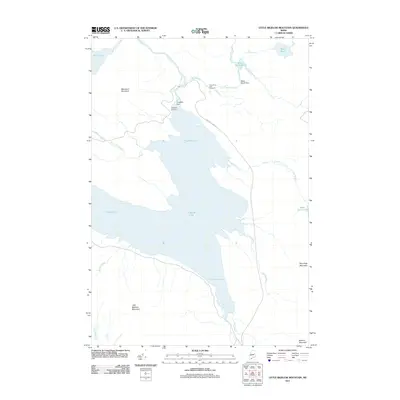
2011 Map of Little Bigelow Mountain
USGS Topo · Published 2011About this map
Flagstaff Lake dominates this landscape, its expansive waters submerging much of the valley between the rising peaks of Little Bigelow Mountain and Blanchard Mountain. Evidence of the managed river system is found at the Longfalls Dam and the smaller Black Brook Dam, which regulate the flow through this part of Franklin County. On the northern shores of the lake, the Flagstaff Cemetery remains a poignant marker of the community that once occupied the basin before the reservoir's creation. The map shows the infrastructure of the Dead River Fish Hatchery near the confluence of Black Brook and the Dead River, highlighting the area's continued reliance on the waterways. To the east, the terrain transitions into smaller water bodies like West Carry Pond and Basin Pond, which lie in the shadow of Roundtop Mountain.
Find a feature on this map
24 named features on this map. Tap any name to fly to it.
Don’t see what you’re looking for? This feature index may not catch every label — zoom into the map to look around manually.
Map Details
Editions of this 2011 Little Bigelow Mountain Map
This is the sole edition of this map. No revisions or reprints were ever made.
Other maps of this area

1925 · Pierce Pond
USGS Topo · 1:48,000

1927 · Pierce Pond
USGS Topo · 1:62,500

1928 · Spencer
USGS Topo · 1:48,000

1928 · Dead River
USGS Topo · 1:62,500

1928 · Stratton
USGS Topo · 1:48,000

1931 · Dead River
USGS Topo · 1:48,000

1932 · Stratton
USGS Topo · 1:62,500

1932 · Spencer
USGS Topo · 1:62,500

1944 · Dead River
USGS Topo · 1:62,500

1944 · Pierce Pond
USGS Topo · 1:62,500
Featured Places
- Carrabassett Valley, ME
- Highland Plantation, ME
- Dead River Township, ME
- Spring Lake Township, ME
- Pierce Pond Township, ME