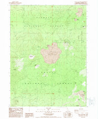
1988 Map of Little Glass Mountain
USGS Topo · Published 1988About this map
Little Glass Mountain dominates this volcanic landscape where the boundaries of the Klamath National Forest, Modoc National Forest, and Shasta National Forest converge. This 1980s-era survey reveals an environment shaped by relatively recent geomorphic activity, notably the Crater Glass Flow and a series of prominent craters including Paint Pot Crater, Shastine Crater, and Giant Crater. The industrial character of the region is evident through the widespread extraction of volcanic materials, marked by the Pumice Mines near Pumice Stone Mountain and several Cinder Pit locations. Water resources are scarce in this porous terrain, limited to remote installations like Bray Well and Pumice Stone Well. High points such as Little Mt Hoffman and Red Cap Mountain provide vantage points over the Grasshopper Flat and the complex obsidian and pumice deposits that define this portion of Siskiyou County.
Find a feature on this map
28 named features on this map. Tap any name to fly to it.
Don’t see what you’re looking for? This feature index may not catch every label — zoom into the map to look around manually.
Map Details
Editions of this 1988 Little Glass Mountain Map
This is the sole edition of this map. No revisions or reprints were ever made.
Other maps of this area

1886 · Modoc Lava Bed
USGS Topo · 1:250,000

1892 · Modoc Lava-Bed
USGS Topo · 1:250,000

1932 · Bartle
USGS Topo · 1:96,000

1939 · Bartle
USGS Topo · 1:125,000

1950 · Bray
USGS Topo · 1:62,500

1952 · Medicine Lake
USGS Topo · 1:62,500

1954 · Alturas
USGS Topo · 1:250,000

1958 · Alturas
USGS Topo · 1:250,000

1961 · Hambone
USGS Topo · 1:62,500

1961 · Bartle
USGS Topo · 1:62,500