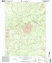
1998 Map of Little Glass Mountain
USGS Topo · Published 2003About this map
Little Glass Mountain dominates this volcanic landscape, where geological history is written in obsidian and ash within the meeting point of the Klamath, Modoc, and Shasta Trinity National Forests. The map documents a territory defined by geothermal activity and timber management, featuring the expansive Crater Glass Flow and the jagged Tilted Rock Lava Flow. Cultural and industrial markers are sparse but significant, including the Little Hoffman Lookout perched for fire surveillance and various Pumice Mines that utilized the area's volcanic deposits. This 1990s revision captures the area's essential infrastructure, from the Bray Well to the specialized Gooseneck Mc Cloud Ranger District roads, providing a clear record of the high-country terrain before modern shifts in forest management.
Find a feature on this map
36 named features on this map. Tap any name to fly to it.
Don’t see what you’re looking for? This feature index may not catch every label — zoom into the map to look around manually.
Map Details
Editions of this 1998 Little Glass Mountain Map
This is the sole edition of this map. No revisions or reprints were ever made.
Other maps of this area

1886 · Modoc Lava Bed
USGS Topo · 1:250,000

1892 · Modoc Lava-Bed
USGS Topo · 1:250,000

1932 · Bartle
USGS Topo · 1:96,000

1939 · Bartle
USGS Topo · 1:125,000

1950 · Bray
USGS Topo · 1:62,500

1952 · Medicine Lake
USGS Topo · 1:62,500

1954 · Alturas
USGS Topo · 1:250,000

1958 · Alturas
USGS Topo · 1:250,000

1961 · Hambone
USGS Topo · 1:62,500

1961 · Bartle
USGS Topo · 1:62,500