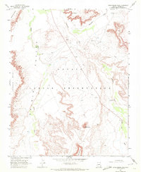
1968 Map of Little Round Rock
USGS Topo · Published 1972About this map
Navajo Indian Reservation lands dominate this 1968 survey of the northern Arizona desert, where the drainage systems of Chinle Wash and Lukachukai Wash carve through the arid floor of the Chinle Valley. The landscape is defined by its distinct geological formations, including the prominent sandstone heights of Little Round Rock and Round Rock near the southern boundary. To the west, the steep escarpment of Carson Mesa rises sharply from the valley, while the northern reaches feature unique natural landmarks like Rock Window overlooking Hasbidito Creek. The presence of several Borrow Pits and isolated water sources such as Flowing Well suggests a land managed for its limited resources, supporting seasonal passage and grazing within this remote corner of Apache County.
Find a feature on this map
13 named features on this map. Tap any name to fly to it.
Don’t see what you’re looking for? This feature index may not catch every label — zoom into the map to look around manually.
Map Details
Editions of this 1968 Little Round Rock Map
This is the sole edition of this map. No revisions or reprints were ever made.
Other maps of this area

1892 · Canyon De Chelly
USGS Topo · 1:250,000

1953 · Los Gigantes NW
USGS Topo · 1:24,000

1953 · Los Gigantes SW
USGS Topo · 1:24,000

1953 · Los Gigantes Buttes
USGS Topo · 1:62,500

1954 · Shiprock
USGS Topo · 1:250,000

1955 · Sonsala Butte 2 NW
USGS Topo · 1:24,000
1955 · Yellowstone Canyon
USGS Topo · 1:62,500

1958 · Shiprock
USGS Topo · 1:250,000

1959 · Shiprock
USGS Topo · 1:250,000

1968 · Rock Point SW
USGS Topo · 1:24,000