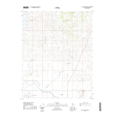
2018 Map of Little Table Mountain
USGS Topo · Published 2018About this map
Madera Canal cuts across the southern portion of this landscape, representing a critical piece of Central Valley water infrastructure. To the north, the terrain rises into the foothills, punctuated by distinctive landmarks like Adobe Hill and the prominent Little Table Mtn. This area reflects a transition from organized agricultural development to the more erratic drainage patterns of Mud Spring Cr and Hildreth Cr. Small settlements and named locales such as Happy Hollow and Wide Awake Ranch Rd suggest a history of ranching and rural habitation. The western edge is defined by the waters of Hensley Lake, a man-made reservoir that serves both as a water resource and a recreational focal point for the region. The network of rural roads, including Rd 406 and Oakwood Rd, provides access to the higher elevations and remote drainages like Cottonwood Cr.
Find a feature on this map
32 named features on this map. Tap any name to fly to it.
Don’t see what you’re looking for? This feature index may not catch every label — zoom into the map to look around manually.
Map Details
Editions of this 2018 Little Table Mountain Map
This is the sole edition of this map. No revisions or reprints were ever made.
Other maps of this area

1912 · Mariposa
USGS Topo · 1:125,000

1916 · Sulphur Springs
USGS Topo · 1:24,000

1919 · Sulphur Springs
USGS Topo · 1:31,680

1919 · Little Table Mountain
USGS Topo · 1:31,680

1921 · Daulton
USGS Topo · 1:31,680

1922 · Lanes Bridge
USGS Topo · 1:31,680

1922 · Friant
USGS Topo · 1:31,680

1922 · Gregg
USGS Topo · 1:31,680

1942 · Raymond
USGS Topo · 1:62,500

1942 · Daulton
USGS Topo · 1:24,000