
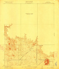
1919 Map of Little Table Mountain
USGS Topo · Published 1919About this map
Little Table Mountain dominates the southern landscape of this 1916 survey, where the rugged topography of Madera County begins to rise. Early 20th-century travel patterns are clearly marked by the intersection of the Madera and Hildreth Road and the Fresno and Yosemite Road, which served as vital corridors for cattle ranching and regional transit before modern highways.
Find a feature on this map
12 named features on this map. Tap any name to fly to it.
Don’t see what you’re looking for? This feature index may not catch every label — zoom into the map to look around manually.
Map Details
Editions of this 1919 Little Table Mountain Map
2 editions found
Other maps of this area

1912 · Mariposa
USGS Topo · 1:125,000

1916 · Sulphur Springs
USGS Topo · 1:24,000

1919 · Sulphur Springs
USGS Topo · 1:31,680

1921 · Daulton
USGS Topo · 1:31,680

1922 · Lanes Bridge
USGS Topo · 1:31,680

1922 · Friant
USGS Topo · 1:31,680

1922 · Gregg
USGS Topo · 1:31,680

1942 · Raymond
USGS Topo · 1:62,500

1942 · Daulton
USGS Topo · 1:24,000

1942 · Little Table Mountain
USGS Topo · 1:24,000