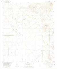
1981 Map of Little Table Top
USGS Topo · Published 1981About this map
The Papago Indian Reservation dominates the southern half of this landscape, where the flat expanse of the Vekol Valley meets the rising peaks of the Table Top Mountains. This 1981 survey documents a desert environment defined by critical water infrastructure and ephemeral drainages, specifically the Vekol Wash and Vekol Valley Wash. These natural corridors were essential for the small pastoral outposts located here, such as the Black Mountain Well and South Vekol Well. The map also captures the precise Maricopa Co Pinal Co boundary as it cuts across the northern desert floor. This area is characterized by the transition from the broad alluvial valley to the dramatic topography of Black Mountain and Little Table Top, providing a clear record of land use and reservation boundaries in this part of the Sonoran desert during the late twentieth century.
Find a feature on this map
14 named features on this map. Tap any name to fly to it.
Don’t see what you’re looking for? This feature index may not catch every label — zoom into the map to look around manually.
Map Details
Editions of this 1981 Little Table Top Map
This is the sole edition of this map. No revisions or reprints were ever made.
Other maps of this area

1941 · Vekol Mountains
USGS Topo · 1:62,500

1942 · Vekol Mountains
USGS Topo · 1:62,500

1946 · Antelope Peak
USGS Topo · 1:62,500

1948 · Antelope Peak
USGS Topo · 1:62,500

1951 · Estrella
USGS Topo · 1:62,500

1953 · Ajo
USGS Topo · 1:250,000

1957 · Ajo
USGS Topo · 1:250,000

1958 · Ajo
USGS Topo · 1:250,000

1958 · Kaka
USGS Topo · 1:62,500

1962 · Ajo
USGS Topo · 1:250,000