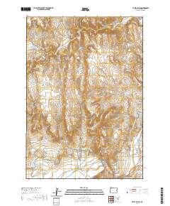
2020 Map of Little Valley
USGS Topo · Published 2020About this map
The Malheur River valley in Malheur County defines this landscape, where the interplay of natural water sources and early twentieth-century engineering projects supports life in the high desert. Historical transportation routes such as the Old Stage Rd and Old Mail Rd cut through the rugged terrain, tracing the paths of early travelers and mail carriers across the interior. The presence of the Vale Oregon Main Canal and the Little Valley Lateral illustrates the critical role of irrigation in sustaining settlements like Little Valley and Harper Valley. Near the river, the Harper Cem and Harper Springs provide specific points of interest for genealogists tracing the legacy of the Harper family. The map also records several natural water features, including Wildhorse Spring and Alkali Spring, which historically served as vital landmarks for both cattle ranching and homesteading in this corner of eastern Oregon.
Find a feature on this map
20 named features on this map. Tap any name to fly to it.
Don’t see what you’re looking for? This feature index may not catch every label — zoom into the map to look around manually.
Map Details
Editions of this 2020 Little Valley Map
This is the sole edition of this map. No revisions or reprints were ever made.
Other maps of this area

1906 · Mitchell Butte
USGS Topo · 1:125,000

1950 · Jamieson
USGS Topo · 1:62,500

1955 · Baker
USGS Topo · 1:250,000

1955 · Boise
USGS Topo · 1:250,000

1958 · Boise
USGS Topo · 1:250,000

1959 · Baker
USGS Topo · 1:250,000

1962 · Boise
USGS Topo · 1:250,000

1964 · Brogan
USGS Topo · 1:62,500

1966 · Harper
USGS Topo · 1:62,500
1967 · Vines Hill
USGS Topo · 1:24,000