
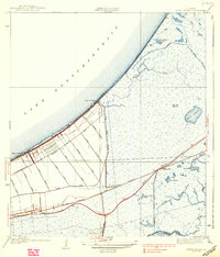
1938 Map of Little Woods
USGS Topo · Published 1938About this map
Lake Pontchartrain defines the northwestern edge of this 1930s coastal landscape, where the rising infrastructure of Orleans Parish meets the marshy expanses of the Louisiana coast. The settlement at Little Woods and the nearby Edge Lake community are shown during a period of transition, linked to the city by the Southern Railway and the development of Hayne Boulevard. A complex network of drainage projects is evident through the numerous artificial waterways including the Janncke Canal, Farrar Canal, and the Little Woods Drainage Canal, which segment the low-lying terrain into organized tracts.
Find a feature on this map
38 named features on this map. Tap any name to fly to it.
Don’t see what you’re looking for? This feature index may not catch every label — zoom into the map to look around manually.
Map Details
Editions of this 1938 Little Woods Map
2 editions found
Other maps of this area

1891 · Spanish Fort
USGS Topo · 1:62,500

1891 · New Orleans
USGS Topo · 1:62,500

1892 · Chef Menteur
USGS Topo · 1:62,500

1892 · St. Bernard
USGS Topo · 1:62,500

1932 · New Orleans NE
USGS Topo · 1:31,680

1936 · North Shore
USGS Topo · 1:31,680

1936 · South Point
USGS Topo · 1:31,680

1936 · Chef Menteur
USGS Topo · 1:62,500

1936 · Spanish Fort
USGS Topo · 1:62,500

1937 · Chef Menteur
USGS Topo · 1:31,680
Featured Places
- New Orleans, LA
- Michoud, New Orleans
- Idlewood, New Orleans
- Versailles, New Orleans
- Kingswood, New Orleans