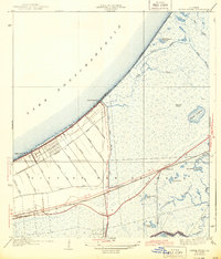
1943 Map of Little Woods
USGS Topo · Published 1943About this map
Lake Pontchartrain defines the northern edge of this coastal landscape, where the marshlands of eastern New Orleans meet the water. During the mid-1930s and early 1940s, a systematic grid of drainage canals including Vincent Canal, Cannon Canal, and Farrar Canal began to define the geography of the lakeside, preparing the area for development. The settlement of Little Woods sits along the Southern Railway corridor following Hayne Boulevard, while further south, the Louisville and Nashville Railroad cuts through the wetlands near Micheaud. The terrain is characterized by a complex network of bayous and lagoons, such as Bayou Sauvage and Blind Lagoon, interspersed with slightly elevated features like Big Oak Island. This map documents a period when the natural hydrology of Orleans Parish was being actively reshaped by industrial infrastructure and road expansion, including Paris Road and Nashville Road.
Find a feature on this map
39 named features on this map. Tap any name to fly to it.
Don’t see what you’re looking for? This feature index may not catch every label — zoom into the map to look around manually.
Map Details
Editions of this 1943 Little Woods Map
This is the sole edition of this map. No revisions or reprints were ever made.
Other maps of this area

1891 · Spanish Fort
USGS Topo · 1:62,500

1891 · New Orleans
USGS Topo · 1:62,500

1892 · Chef Menteur
USGS Topo · 1:62,500

1892 · St. Bernard
USGS Topo · 1:62,500

1932 · New Orleans NE
USGS Topo · 1:31,680

1936 · North Shore
USGS Topo · 1:31,680

1936 · South Point
USGS Topo · 1:31,680

1936 · Chef Menteur
USGS Topo · 1:62,500

1936 · Spanish Fort
USGS Topo · 1:62,500

1937 · Chef Menteur
USGS Topo · 1:31,680
Featured Places
- New Orleans, LA
- Michoud, New Orleans
- Idlewood, New Orleans
- Versailles, New Orleans
- Kingswood, New Orleans