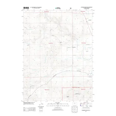
2013 Map of Livermore Mountain
USGS Topo · Published 2013About this map
The North Fork Cache La Poudre River and its numerous tributaries, including Rabbit Creek and Lone Pine Creek, define the drainage patterns of this Larimer County landscape. Settled around the junction of Us-287 N and Red Feather Lakes Rd, the community of Livermore serves as a central point for the surrounding ranchlands and foothills. For genealogists and local historians, the area is rich with family-named landmarks and resting places, such as the Lamb Family Cem and the Elliott Ranch Cem. Evidence of early travel and commerce is preserved in labels like the Cherokee Stage Station Cem along the historic route. To the south, the terrain rises into the Roosevelt National Forest, where Livermore Mountain stands as a prominent feature overlooking the diverse water systems, including the N Poudre Canal and Upper Stonewall Reservoir.
Find a feature on this map
35 named features on this map. Tap any name to fly to it.
Don’t see what you’re looking for? This feature index may not catch every label — zoom into the map to look around manually.
Map Details
Editions of this 2013 Livermore Mountain Map
This is the sole edition of this map. No revisions or reprints were ever made.
Other maps of this area

1906 · Fort Collins
USGS Topo · 1:62,500

1907 · Livermore
USGS Topo · 1:125,000

1908 · Fort Collins
USGS Topo · 1:62,500

1909 · Livermore
USGS Topo · 1:125,000

1954 · Greeley
USGS Topo · 1:250,000

1957 · Greeley
USGS Topo · 1:250,000

1958 · Greeley
USGS Topo · 1:250,000

1960 · Livermore
USGS Topo · 1:24,000

1960 · Haystack Gulch
USGS Topo · 1:24,000

1960 · Livermore Mountain
USGS Topo · 1:24,000