
1930 Map of Llano
USGS Topo · Published 1930About this map
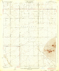
Antelope Valley dominates this 1930 advance sheet, revealing a landscape defined by desert hydrology and early territorial surveying. The broad sweep of Big Rock Wash cuts diagonally across the terrain, illustrating the seasonal drainage patterns that shaped local development before modern water management. The map highlights the early transition from a remote desert expanse to a structured settlement area, anchored by the First Standard Parallel North and a growing network of thoroughfares like Harding Road and Llano Wilsona Road. Distinctive natural landmarks such as Lovejoy Buttes provide vertical contrast to the valley floor, while the settlement at Llano and the curious Desert Relief designation offer points of interest for genealogists and local historians tracking the high desert’s early twentieth-century footprint.
Find a feature on this map
11 named features on this map. Tap any name to fly to it.
Don’t see what you’re looking for? This feature index may not catch every label — zoom into the map to look around manually.
Map Details
Editions of this 1930 Llano Map
This is the sole edition of this map. No revisions or reprints were ever made.
Other maps of this area

1901 · Southern California Sheet No. 1
USGS Topo · 1:250,000

1903 · Rock Creek
USGS Topo · 1:62,500

1904 · Southern California Sheet No. 1
USGS Topo · 1:250,000

1930 · Lovejoy Springs
USGS Topo · 1:24,000

1930 · Black Butte
USGS Topo · 1:24,000

1930 · Little Rock
USGS Topo · 1:24,000

1930 · West Alpine Butte
USGS Topo · 1:24,000

1930 · Wilsona
USGS Topo · 1:24,000

1933 · Lovejoy Springs
USGS Topo · 1:24,000
1933 · West Alpine Butte
USGS Topo · 1:24,000