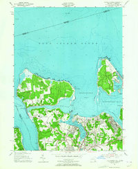
1954 Map of Lloyd Harbor
USGS Topo · Published 1964About this map
Lloyd Neck and Eatons Neck dominate this mid-century coastal landscape, their wooded peninsulas sheltering the deep waters of Lloyd Harbor and Huntington Bay. The 1954 cultural revision shows a region balancing grand estates and institutional grounds with post-war suburban growth. Landmarks like Immaculate Conception Seminary and the historic Fort Hill stand on high ground, while the harbor shores are dotted with private clubs like the Huntington Yacht Club and the Huntington Crescent Club Beach. In the villages of Halesite and Centerport, the transition from maritime industry to residential living is evident. Notable local infrastructure includes a Shipyard near Halesite, the Huntington Hospital, and several local schools such as Saint Patricks Sch and Ketewomoke Sch, providing a clear view of the community's social fabric before further late-century development.
Find a feature on this map
73 named features on this map. Tap any name to fly to it.
Don’t see what you’re looking for? This feature index may not catch every label — zoom into the map to look around manually.
Map Details
Editions of this 1954 Lloyd Harbor Map
2 editions found
Other maps of this area

1892 · Stamford
USGS Topo · 1:62,500

1892 · Norwalk
USGS Topo · 1:62,500

1893 · Stamford
USGS Topo · 1:62,500

1893 · Norwalk
USGS Topo · 1:62,500

1897 · Oyster Bay
USGS Topo · 1:62,500

1898 · Oyster Bay
USGS Topo · 1:62,500

1899 · Stamford
USGS Topo · 1:62,500

1900 · Oyster Bay
USGS Topo · 1:62,500

1901 · Northport
USGS Topo · 1:62,500

1903 · Northport
USGS Topo · 1:62,500