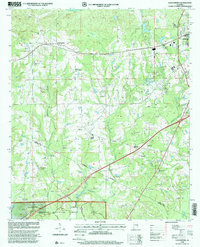
1998 Map of Loachapoka
USGS Topo · Published 2001About this map
Loachapoka stands at the heart of this landscape, its residential core supported by the Loachapoka Jr High Sch and a series of historic burial sites, including the Loachapoka Cem. The surrounding territory is defined by a dense network of country churches like Pleasant View Ch and St Matthew Ch, reflecting the rural community's social structure. To the south, the terrain descends into the wooded reaches of the Tuskegee National Forest, where the Choctafaula Creek carves a path through the timberland. Along the eastern edge, the expansion of Auburn is visible through modern developments and the Pin Oaks Country Club, while the central areas remain dominated by resource extraction, evidenced by numerous Gravel Pits. The map documents the persistent rural character of the Lee and Macon county border before suburban growth reached these western reaches.
Find a feature on this map
29 named features on this map. Tap any name to fly to it.
Don’t see what you’re looking for? This feature index may not catch every label — zoom into the map to look around manually.
Map Details
Editions of this 1998 Loachapoka Map
This is the sole edition of this map. No revisions or reprints were ever made.
Other maps of this area

1906 · Dadeville
USGS Topo · 1:125,000

1907 · Opelika
USGS Topo · 1:125,000

1909 · Opelika
USGS Topo · 1:125,000

1955 · Phenix City
USGS Topo · 1:250,000

1957 · Phenix City
USGS Topo · 1:250,000

1958 · Phenix City
USGS Topo · 1:250,000

1971 · Waverly
USGS Topo · 1:24,000

1971 · Little Texas
USGS Topo · 1:24,000
1971 · Opelika West
USGS Topo · 1:24,000

1971 · Loachapoka
USGS Topo · 1:24,000