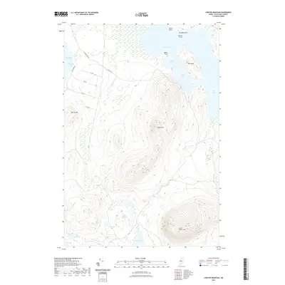
2021 Map of Lobster Mountain
USGS Topo · Published 2021About this map
Lobster Mtn and Little Spencer Mtn anchor this Piscataquis County landscape, where the northern reaches of Moosehead Lake transition into a complex network of glacial ponds and timberlands. The northeastern edge of the sheet is dominated by Lobster Lake, characterized by its jagged shoreline features like Big Island, Little Claw, and Jackson Cove. This area reflects the modern management of Maine's North Woods, where a grid of rural logging routes including Co RD 1 and Halfway Rd provide access to remote water bodies like Spencer Pond and Tom Young Pond. The terrain is defined by prominent elevations like Norcross Mtn that overlook the boggy lowlands of Halfway Brook, illustrating the classic interior wilderness character of the Northeast Cove region.
Find a feature on this map
26 named features on this map. Tap any name to fly to it.
Don’t see what you’re looking for? This feature index may not catch every label — zoom into the map to look around manually.
Map Details
Editions of this 2021 Lobster Mountain Map
This is the sole edition of this map. No revisions or reprints were ever made.
Other maps of this area

1920 · Moosehead Lake
USGS Topo · 1:62,500

1922 · Moosehead Lake
USGS Topo · 1:62,500

1930 · Moosehead Lake
USGS Topo · 1:62,500

1944 · Moosehead Lake
USGS Topo · 1:62,500

1952 · First Roach Pond
USGS Topo · 1:62,500

1954 · North East Carry
USGS Topo · 1:62,500

1954 · Grant Farm
USGS Topo · 1:62,500

1954 · Millinocket
USGS Topo · 1:250,000

1957 · Moosehead Lake
USGS Topo · 1:62,500

1958 · Millinocket
USGS Topo · 1:250,000
Featured Places
- Northeast Carry Township, ME
- TX R14 WELS, ME
- East Middlesex Canal Grant Township, ME
- Lobster Township, ME
- Piscataquis County, ME