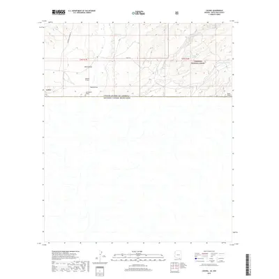
2018 Map of Lochiel
USGS Topo · Published 2018About this map
The tiny border community of Lochiel sits at the very edge of the Arizona-Mexico frontier, marking a unique point where the high grasslands of the San Rafael Valley meet the international boundary. This landscape is defined by its drainage patterns and water management, with numerous cattle tanks such as Arlene Tank, Huachuca Tank, and Kenny Tank scattered across the basin to support ranching in this arid environment. To the east, the terrain rises into the foothills of the Coronado National Forest, where deep incisions like Adams Canyon, Antonio Canyon, and Bodie Canyon carve through the earth. The map illustrates a remote intersection of geography and politics, with the United States and Mexico border cutting a straight line across the natural southern flow of Hayfield Draw and other seasonal watercourses.
Find a feature on this map
17 named features on this map. Tap any name to fly to it.
Don’t see what you’re looking for? This feature index may not catch every label — zoom into the map to look around manually.
Map Details
Editions of this 2018 Lochiel Map
This is the sole edition of this map. No revisions or reprints were ever made.
Other maps of this area

1905 · Nogales
USGS Topo · 1:125,000

1914 · Hereford
USGS Topo · 1:125,000

1922 · Sunnyside
USGS Topo · 1:62,500

1932 · Lochiel
USGS Topo · 1:62,500

1938 · Sunnyside
USGS Topo · 1:62,500

1948 · Canelo Pass
USGS Topo · 1:24,000

1948 · Huachuca Peak
USGS Topo · 1:24,000
1948 · Sunnyside SW
USGS Topo · 1:24,000
1948 · Lochiel SE
USGS Topo · 1:24,000

1948 · Harshaw
USGS Topo · 1:24,000