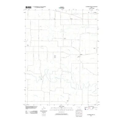
2010 Map of Lockridge West
USGS Topo · Published 2010About this map
Cedar Creek and Wolf Creek define the drainage of this Jefferson County landscape, where the rural topography is dotted with a remarkably high concentration of small burial grounds. From the Pioneer Cemetery in the southwest to the Jones Family Cemetery near the center, these sites reflect generations of local families. The settlement at Glasgow sits at a junction of county roads, while the northern edge includes the town of Lockridge and the distinct location of Coal Port. The terrain transitions from flat uplands divided by an orderly grid of timber-named roads like Tamarack Ave and Spruce Ave to the winding, wooded riparian zones of Summer Creek and Rock Creek. These waterways and the scattered plots like Bonnifield Cemetery and Mount Zion Cemetery reveal the intersection of pioneer-era settlement patterns and modern agricultural land use.
Find a feature on this map
55 named features on this map. Tap any name to fly to it.
Don’t see what you’re looking for? This feature index may not catch every label — zoom into the map to look around manually.
Map Details
Editions of this 2010 Lockridge West Map
This is the sole edition of this map. No revisions or reprints were ever made.
Other maps of this area

1958 · Burlington
USGS Topo · 1:250,000

1958 · Davenport
USGS Topo · 1:250,000

1961 · Burlington
USGS Topo · 1:250,000

1961 · Davenport
USGS Topo · 1:250,000

1962 · Davenport
USGS Topo · 1:250,000

1963 · Burlington
USGS Topo · 1:250,000
1980 · Fairfield North
USGS Topo · 1:24,000
1980 · Fairfield South
USGS Topo · 1:24,000

1980 · Lockridge West
USGS Topo · 1:24,000

1980 · Trenton
USGS Topo · 1:24,000