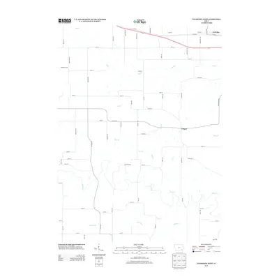
2013 Map of Lockridge West
USGS Topo · Published 2013About this map
Glasgow and the western edge of Lockridge anchor this Jefferson County landscape, where the agricultural grid meets the winding drainages of the Cedar Cr and Summer Cr valleys. The terrain is defined by a dense network of watercourses, including Wolf Cr and Rock Cr, which bisect the rectilinear section roads. A notable local landmark, Coal Port, is situated along the northern corridor near the crossing of Varnishtree Ave. The map illustrates a mature rural infrastructure, where road names like Glasgow Rd and Peppermint Blvd provide clear geographic markers for researchers tracing local property lines or family farmsteads. The transition from the high, flat farmland into the wooded creek bottoms of Jones Br and Berry Br highlights the natural drainage patterns that have influenced land use in this part of Southeast Iowa for generations.
Find a feature on this map
61 named features on this map. Tap any name to fly to it.
Don’t see what you’re looking for? This feature index may not catch every label — zoom into the map to look around manually.
Map Details
Editions of this 2013 Lockridge West Map
This is the sole edition of this map. No revisions or reprints were ever made.
Other maps of this area

1958 · Burlington
USGS Topo · 1:250,000

1958 · Davenport
USGS Topo · 1:250,000

1961 · Burlington
USGS Topo · 1:250,000

1961 · Davenport
USGS Topo · 1:250,000

1962 · Davenport
USGS Topo · 1:250,000

1963 · Burlington
USGS Topo · 1:250,000
1980 · Fairfield North
USGS Topo · 1:24,000
1980 · Fairfield South
USGS Topo · 1:24,000

1980 · Lockridge West
USGS Topo · 1:24,000

1980 · Trenton
USGS Topo · 1:24,000