1956 Map of Lockwood
USGS Topo · Published 1957About this map
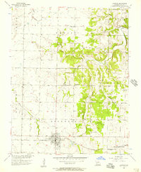
Lockwood serves as the primary hub in this mid-century portrait of southwestern Dade County, where the St Louis San Francisco Railroad railroad cuts a straight line through the agricultural prairie. The township structure is clearly delineated, showing the intersection of Ernest, North, and Lockwood districts. Rural life is anchored by a network of country churches and family burial grounds, such as Mt Nebo Ch and Messick Cem, many situated near the winding drainage of Horse Creek and its various tributaries like Lobby Prong. The presence of the Immanuel Cem and Sewage Disposal facilities at the edge of the main town site reflects a community balanced between its pioneer roots and modern infrastructure requirements of the 1950s.
Find a feature on this map
27 named features on this map. Tap any name to fly to it.
Don’t see what you’re looking for? This feature index may not catch every label — zoom into the map to look around manually.
Map Details
Editions of this 1956 Lockwood Map
This is the sole edition of this map. No revisions or reprints were ever made.
Other maps of this area

1886 · Nevada
USGS Topo · 1:125,000

1886 · Stockton
USGS Topo · 1:125,000

1886 · Greenfield
USGS Topo · 1:125,000

1886 · Carthage
USGS Topo · 1:125,000

1888 · Greenfield
USGS Topo · 1:125,000

1894 · Nevada
USGS Topo · 1:125,000

1894 · Carthage
USGS Topo · 1:125,000

1947 · Joplin
USGS Topo · 1:250,000

1949 · Joplin
USGS Topo · 1:250,000

1954 · Springfield
USGS Topo · 1:250,000