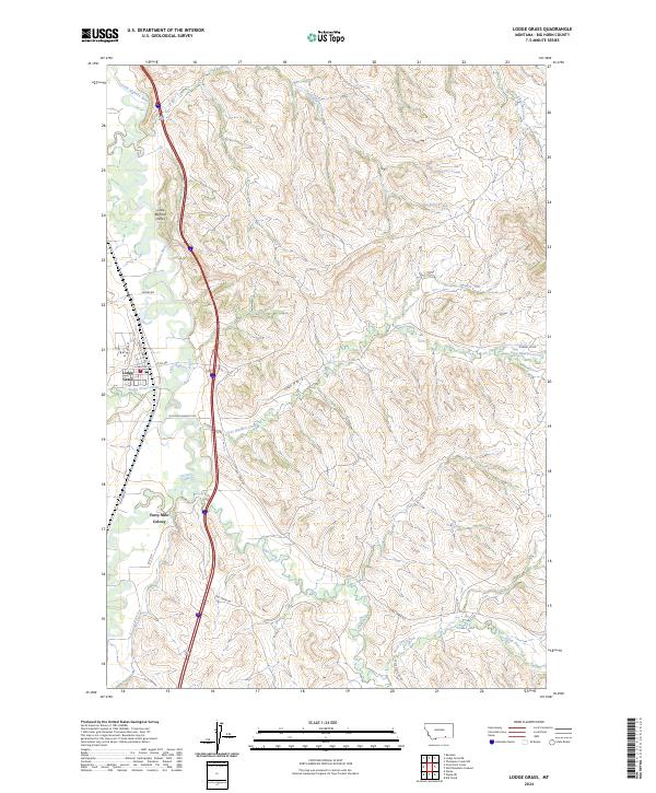
2024 Map of Lodge Grass
USGS Topo · Published 2024About this map
The Little Bighorn River flows through the western portion of this Montana landscape, anchoring the community of Lodge Grass. This region in Big Horn County is defined by its creek valleys and agricultural infrastructure, notably the Fortymile Canal which services the area south of the Forty Mile Colony. The topography is marked by a series of drainages, including Slaughter Creek, Grey Blanket Creek, and Owl Creek, which cut through the rising terrain east of the main river valley. Local transportation is represented by a network of named routes such as Nomee Rd, Corral Cr Rd, and the bypassed segment of Old Hwy 87. The mapping also delineates the Little Bighorn Valley, reflecting the enduring importance of this waterway to the settlement patterns and land use in this part of the state.
Find a feature on this map
28 named features on this map. Tap any name to fly to it.
Don’t see what you’re looking for? This feature index may not catch every label — zoom into the map to look around manually.
Map Details
Editions of this 2024 Lodge Grass Map
This is the sole edition of this map. No revisions or reprints were ever made.
Other maps of this area

1894 · Rosebud
USGS Topo · 1:125,000

1901 · Rosebud
USGS Topo · 1:125,000

1954 · Hardin
USGS Topo · 1:250,000

1957 · Hardin
USGS Topo · 1:250,000

1958 · Hardin
USGS Topo · 1:250,000

1967 · Lodge Grass NE
USGS Topo · 1:24,000

1967 · Kid Creek
USGS Topo · 1:24,000

1967 · Wolf Mountain Lookout
USGS Topo · 1:24,000
1967 · Wyola
USGS Topo · 1:24,000
1967 · Benteen
USGS Topo · 1:24,000