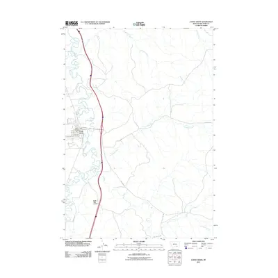
2011 Map of Lodge Grass
USGS Topo · Published 2011About this map
The Little Bighorn River meanders through this portion of Big Horn County, Montana, defining the local geography alongside tributaries such as Slaughter Creek and Sunday Creek. The settlement of Lodge Grass serves as a central hub, featuring a grid of streets including Main St and Hester, as well as the Lodge Grass Post Office and Lodge Grass Vol Fire Dept. Further south, the Forty Mile Colony stands near the Fortymile Canal, indicating a distinct pattern of agricultural or community development along the valley floor. The landscape is marked by a network of drainage systems like Grey Blanket Creek and Sioux Pass Creek, which flow toward the primary river valley. Rural transportation routes such as Gray Blanket Rd and Owl Creek Rd provide access to the surrounding uplands and drainage basins, reflecting the area's long-standing reliance on its water networks.
Find a feature on this map
22 named features on this map. Tap any name to fly to it.
Don’t see what you’re looking for? This feature index may not catch every label — zoom into the map to look around manually.
Map Details
Editions of this 2011 Lodge Grass Map
This is the sole edition of this map. No revisions or reprints were ever made.
Other maps of this area

1894 · Rosebud
USGS Topo · 1:125,000

1901 · Rosebud
USGS Topo · 1:125,000

1954 · Hardin
USGS Topo · 1:250,000

1957 · Hardin
USGS Topo · 1:250,000

1958 · Hardin
USGS Topo · 1:250,000

1967 · Lodge Grass NE
USGS Topo · 1:24,000

1967 · Kid Creek
USGS Topo · 1:24,000

1967 · Wolf Mountain Lookout
USGS Topo · 1:24,000
1967 · Wyola
USGS Topo · 1:24,000
1967 · Benteen
USGS Topo · 1:24,000