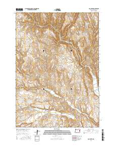
2017 Map of Log Creek
USGS Topo · Published 2017About this map
Log Creek Basin anchors the northeast corner of this high-desert landscape in Malheur County, where the management of water is the primary human imprint on the land. The terrain is defined by a series of drainages and reservoirs, including Log Cr Basin Reservoir and Becker Reservoir, which support life in this arid region. The network of canyons, such as Hay Canyon and Timber Canyon, reveals a rugged geography carved by seasonal flows like Bully Cr and its various forks. Roadways like Bonita Rd and Scott Rd provide the only access through this expansive country, connecting isolated points like Richie Flat. The map illustrates a classic Great Basin ranching environment, where cattle and wildlife depend on artificial catchments such as Ridge Road Reservoir and Saddle Reservoir to endure the dry climate.
Find a feature on this map
23 named features on this map. Tap any name to fly to it.
Don’t see what you’re looking for? This feature index may not catch every label — zoom into the map to look around manually.
Map Details
Editions of this 2017 Log Creek Map
This is the sole edition of this map. No revisions or reprints were ever made.
Other maps of this area

1955 · Baker
USGS Topo · 1:250,000

1955 · Boise
USGS Topo · 1:250,000

1958 · Boise
USGS Topo · 1:250,000

1959 · Baker
USGS Topo · 1:250,000

1962 · Boise
USGS Topo · 1:250,000

1964 · Brogan
USGS Topo · 1:62,500

1966 · Clover Creek Ranch
USGS Topo · 1:62,500

1966 · Harper
USGS Topo · 1:62,500

1966 · Westfall Butte
USGS Topo · 1:62,500

1980 · Brogan
USGS Topo · 1:100,000