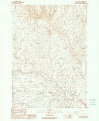
1990 Map of Log Creek
USGS Topo · Published 1990About this map
Bully Creek and its complex drainage system, including the North Fork and South Fork, define this high-desert landscape in Malheur County. The map documents a sophisticated network of water management essential for ranching, featuring the Log Creek Basin Reservoir, Jordan Reservoir, and Saddle Reservoir. Ranching history is further evidenced by several Corrals and an Abandoned Airstrip near Gregory Gulch, signaling the scale of remote land operations during the late twentieth century. Diverse terrain features like Hay Canyon, Deep Canyon, and Richie Flat break the plateau, while a solitary Cem stands as a marker of the area's early residents. This provisional survey provides a precise look at the infrastructure of the Oregon interior before many such remote sites were modernized or altered.
Find a feature on this map
19 named features on this map. Tap any name to fly to it.
Don’t see what you’re looking for? This feature index may not catch every label — zoom into the map to look around manually.
Map Details
Editions of this 1990 Log Creek Map
This is the sole edition of this map. No revisions or reprints were ever made.
Other maps of this area

1955 · Baker
USGS Topo · 1:250,000

1955 · Boise
USGS Topo · 1:250,000

1958 · Boise
USGS Topo · 1:250,000

1959 · Baker
USGS Topo · 1:250,000

1962 · Boise
USGS Topo · 1:250,000

1964 · Brogan
USGS Topo · 1:62,500

1966 · Clover Creek Ranch
USGS Topo · 1:62,500

1966 · Harper
USGS Topo · 1:62,500

1966 · Westfall Butte
USGS Topo · 1:62,500

1980 · Brogan
USGS Topo · 1:100,000