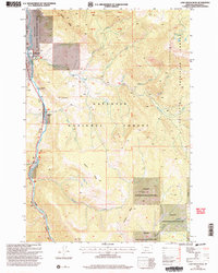
2000 Map of Lone Indian Peak
USGS Topo · Published 2005About this map
Lone Indian Peak stands as the high point in this survey of the mountainous terrain south of Big Sky, where the headwaters of the Gallatin River carve a narrow corridor through the Gallatin National Forest. This era shows a landscape managed for both timber and wildlife, evidenced by the extensive Gallatin State Wildlife Management Area and the unique designation of the Petrified Forest along the eastern ridges. Along the valley floor, US Highway 191 follows the river's path, passing the Rainbow Ranch and the State Highway Department facility, which served as essential infrastructure for the region's increasing recreational and transit importance. A network of drainage systems including First Creek, Second Creek, Third Creek, and Fourth Creek descend from the high timberline toward the main river. These drainages, along with named ridges like Levinski Ridge and Blizzard Ridge, define the complex topography that surrounds the seasonal settlement at Lemondrop.
Find a feature on this map
28 named features on this map. Tap any name to fly to it.
Don’t see what you’re looking for? This feature index may not catch every label — zoom into the map to look around manually.
Map Details
Editions of this 2000 Lone Indian Peak Map
This is the sole edition of this map. No revisions or reprints were ever made.
Other maps of this area

1888 · Three Forks
USGS Topo · 1:250,000

1894 · Three Forks
USGS Topo · 1:250,000

1895 · Three Forks
USGS Topo · 1:250,000

1947 · Bozeman
USGS Topo · 1:250,000

1948 · Bozeman
USGS Topo · 1:250,000

1950 · Spanish Peaks
USGS Topo · 1:62,500

1950 · Sphinx Mountain
USGS Topo · 1:62,500

1955 · Bozeman
USGS Topo · 1:250,000

1955 · Garnet Mountain
USGS Topo · 1:62,500

1955 · Crown Butte
USGS Topo · 1:62,500