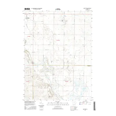
2015 Map of Lone Tree
USGS Topo · Published 2015About this map
Lone Tree and the surrounding farmland of southern Johnson County are defined by the winding course of the Iowa River as it flows toward the Louisa County line. This 2015 survey reveals a landscape deeply connected to its pioneers and early settlers, evidenced by the high density of small family and community burial grounds dotting the townships. From the Evans Cem in the north to the Foster Cem and Saint Pauls Cem near the river, these sites provide a vital record for genealogical research in Fremont and Pleasant Valley. The river valley itself is a complex of wetlands and secondary water bodies, including McDowell Lake, Hockeys Slough, and the historical Hills Lake. This network of oxbows and creeks like Otter Cr and Prairie Cr illustrates the shifting hydrology of the Iowa River floodplain before modern drainage altered much of the regional terrain.
Find a feature on this map
61 named features on this map. Tap any name to fly to it.
Don’t see what you’re looking for? This feature index may not catch every label — zoom into the map to look around manually.
Map Details
Editions of this 2015 Lone Tree Map
This is the sole edition of this map. No revisions or reprints were ever made.
Other maps of this area

1891 · Iowa City
USGS Topo · 1:62,500

1894 · West Liberty
USGS Topo · 1:62,500

1901 · Stanwood
USGS Topo · 1:125,000

1903 · Fairfax
USGS Topo · 1:125,000

1938 · Iowa City
USGS Topo · 1:62,500

1958 · Davenport
USGS Topo · 1:250,000

1961 · Davenport
USGS Topo · 1:250,000

1962 · Davenport
USGS Topo · 1:250,000
1965 · West Liberty
USGS Topo · 1:24,000
1965 · West Liberty SW
USGS Topo · 1:24,000