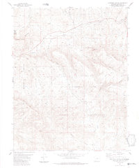
1984 Map of Lonetree Canyon
USGS Topo · Published 1984About this map
Southern Ute Indian Reservation lands dominate the southern half of this landscape, where the high-altitude terrain is carved by a complex network of drainages. The small settlement of Altura sits at the center of the sheet, positioned near the divide between the reservation and the San Juan National Forest. Historical land use is evident in the transition from the Devil Creek State Wildlife Area in the northwest to the livestock-oriented Piedra Stock Trail traversing the rugged canyons.
Find a feature on this map
21 named features on this map. Tap any name to fly to it.
Don’t see what you’re looking for? This feature index may not catch every label — zoom into the map to look around manually.
Map Details
Editions of this 1984 Lonetree Canyon Map
This is the sole edition of this map. No revisions or reprints were ever made.
Other maps of this area

1924 · Pagosa Springs
USGS Topo · 1:125,000

1927 · Pagosa Springs
USGS Topo · 1:125,000

1945 · Durango
USGS Topo · 1:250,000

1953 · Durango
USGS Topo · 1:250,000

1954 · Durango
USGS Topo · 1:250,000

1954 · Carracas
USGS Topo · 1:24,000

1957 · Pagosa Junction
USGS Topo · 1:62,500

1961 · Durango
USGS Topo · 1:250,000

1963 · Durango
USGS Topo · 1:250,000
1964 · Chris Mountain
USGS Topo · 1:24,000