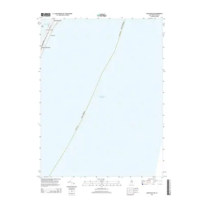
2014 Map of Long Beach NE
USGS Topo · Published 2014About this map
Barnegat Light stands at the northern tip of Long Beach Island, marking the threshold between the Atlantic Ocean and the sheltered waters of Barnegat Bay. This 2014 survey captures the coastal geography of a narrow barrier beach strip, where the local street grid is defined by Long Beach Blvd, Bayview Ave, and Central Ave. The map highlights the proximity of the residential settlement at Long Beach Park to the fragile wetlands of Vol Sedge, illustrating the delicate balance of habitation on this exposed Jersey Shore landscape. Most of the quadrangle is occupied by the open ocean, emphasizing the isolation of the northern island communities and the maritime orientation of Long Beach.
Find a feature on this map
11 named features on this map. Tap any name to fly to it.
Don’t see what you’re looking for? This feature index may not catch every label — zoom into the map to look around manually.
Map Details
Editions of this 2014 Long Beach NE Map
This is the sole edition of this map. No revisions or reprints were ever made.
Other maps of this area

1888 · Barnegat
USGS Topo · 1:62,500

1888 · Long Beach
USGS Topo · 1:62,500

1893 · Long Beach
USGS Topo · 1:62,500

1893 · Barnegat
USGS Topo · 1:62,500

1898 · Barnegat
USGS Topo · 1:62,500

1919 · Long Beach
USGS Topo · 1:62,500

1919 · Barnegat
USGS Topo · 1:62,500

1941 · Toms River
USGS Topo · 1:62,500
1941 · Long Beach
USGS Topo · 1:62,500

1946 · Wilmington
USGS Topo · 1:250,000