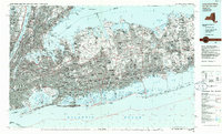
1984 Map of Long Island West
USGS Topo · Published 1986About this map
The Long Island suburban landscape is shown here in detail during a period of significant post-war development and infrastructure expansion. This 1:100,000-scale survey captures the dense residential grids of Levittown and Hempstead as they transition into the more wooded environments of Huntington and Smithtown to the east. The map emphasizes the critical transportation corridors that fueled this growth, including the Long Island Expwy, the Sunrise Hwy, and the extensive network of the Long Island RR.
Find a feature on this map
49 named features on this map. Tap any name to fly to it.
Don’t see what you’re looking for? This feature index may not catch every label — zoom into the map to look around manually.
Map Details
Editions of this 1984 Long Island West Map
2 editions found
Other maps of this area

1888 · Paterson
USGS Topo · 1:62,500

1888 · Sandy Hook
USGS Topo · 1:62,500

1889 · Brooklyn
USGS Topo · 1:62,500

1891 · Ramapo
USGS Topo · 1:62,500

1891 · Brooklyn
USGS Topo · 1:62,500

1891 · Harlem
USGS Topo · 1:62,500

1891 · Bridgeport
USGS Topo · 1:62,500

1892 · Stamford
USGS Topo · 1:62,500

1892 · Norwalk
USGS Topo · 1:62,500

1892 · Paterson
USGS Topo · 1:62,500