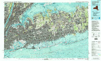
1984 Map of Long Island West
USGS Topo · Published 1988About this map
The Long Island Rail Road corridors and heavy suburban development of the mid-1980s define this topographic study of western Long Island. Spanning from the Hudson River to Port Jefferson, the map documents the dense residential and industrial expansion across Nassau and Suffolk counties. Major infrastructure projects like the Long Island Expressway and the Northern State Parkway weave together established coastal communities such as Glen Cove and inland post-war hubs like Levittown.
Find a feature on this map
80 named features on this map. Tap any name to fly to it.
Don’t see what you’re looking for? This feature index may not catch every label — zoom into the map to look around manually.
Map Details
Editions of this 1984 Long Island West Map
2 editions found
Other maps of this area

1888 · Paterson
USGS Topo · 1:62,500

1888 · Sandy Hook
USGS Topo · 1:62,500

1889 · Brooklyn
USGS Topo · 1:62,500

1891 · Ramapo
USGS Topo · 1:62,500

1891 · Brooklyn
USGS Topo · 1:62,500

1891 · Harlem
USGS Topo · 1:62,500

1891 · Bridgeport
USGS Topo · 1:62,500

1892 · Stamford
USGS Topo · 1:62,500

1892 · Norwalk
USGS Topo · 1:62,500

1892 · Paterson
USGS Topo · 1:62,500